
Nepal’s devastating floods expose the Himalayas’ hidden risks. Learn key disaster preparedness lessons India and its hill states must act on now.
Himalayan Disaster Preparedness: What Nepal’s Catastrophic Floods Are Teaching Us
Introduction
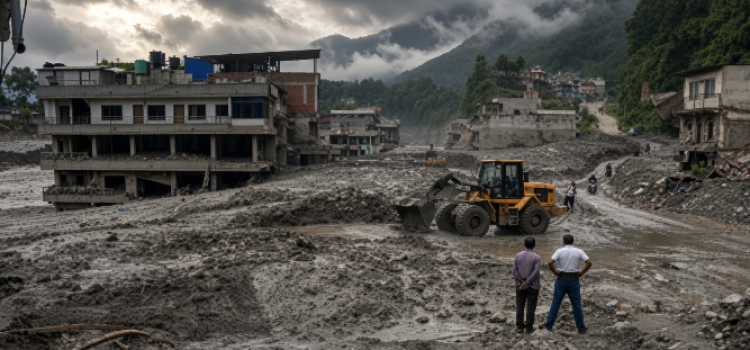
Late in August 2026, the mountains around the Bhotekoshi and Trishuli rivers in Nepal turned violent. Within minutes, walls of water, ice, rock and debris tore through villages, roads and hydropower infrastructure, leaving hundreds dead or missing and entire settlements submerged. For people watching from neighbouring India, Bhutan, Pakistan and beyond, the images were more than a distant tragedy. They were a warning written across the same mountain range that feeds their rivers, powers their dams and shelters millions of their own citizens.

The Himalayas have always been geologically restless, but what unfolded in Nepal was not an ordinary monsoon flood. Preliminary assessments point to a rare, high-altitude chain reaction involving glacier instability, rockfall, a blocked river channel and a sudden catastrophic release of water and debris. Experts increasingly describe this as a new generation of cascading hazards — one where a single trigger point sets off a sequence of events that overwhelms everything downstream before any warning can be issued. Understanding why this happened, and what can be done differently, matters far beyond Nepal’s borders.
Why the Himalayas Are Becoming More Dangerous
A Changing Mountain Ecosystem
Scientists are cautious about attaching every single flood or landslide to climate change, since mountain hazards have complex, layered causes. But the broader trend across the Himalayan belt is difficult to ignore. Glaciers are retreating, snow patterns are shifting, permafrost that once held slopes together is weakening, and river systems are behaving unpredictably. Together, these changes are quietly rewriting the risk map of the entire region, creating new possibilities for the kind of compound disaster Nepal just experienced.
Researchers who track glacial and hydropower risk note that ice, meltwater and loosened rock can now combine within minutes to create flash floods far more powerful than anything local infrastructure was designed to handle. This is not a slow-moving, decades-away threat. It is already happening, and it is happening faster than most disaster-management systems were built to respond to.
Settlements Built Along the Danger Zone
Part of the vulnerability is historical rather than purely climatic. Communities across the Himalayan foothills have long settled close to river corridors, partly because valley floors offered flatter land, easier transport and, in earlier centuries, protection from disease-prone lowlands. That settlement pattern made sense generations ago. Today, with rivers swelling faster and more violently than before, the same river-hugging towns and hydropower stations sit directly in the path of danger.

This is not unique to Nepal. Several Indian hill states sit on the same fault-riddled, glacier-fed terrain, including Jammu and Kashmir, Himachal Pradesh, Uttarakhand and the districts of North Bengal that border the eastern Himalaya. In each of these places, a similar combination of problems keeps resurfacing after every heavy monsoon: rivers that rise within hours rather than days, hillsides weakened by construction and deforestation, drains and culverts built for a gentler era of rainfall, and new buildings going up in low-lying or slide-prone spots simply because the flatter land is easier to develop. When disaster strikes one part of the Himalayan belt, it is rarely an isolated event; it is a preview of what other parts of the same mountain system could face.
Key Lessons From Nepal’s Flood Catastrophe
1. Nature Does Not Wait for Governance to Catch Up
One of the clearest lessons from Nepal is timing. Disaster planning, funding approvals and infrastructure upgrades in most Himalayan regions move at bureaucratic speed, while glacial and hydrological hazards now move at the speed of a landslide. Waiting for the “right” budget cycle or the next monsoon review meeting is no longer a viable strategy in a region where cascading hazards can develop within minutes.
2. Early Warning and Real-Time Information Sharing Are Non-Negotiable
Disaster-management experts consistently point to one gap above all others: the lack of continuous, real-time information exchange, both within countries and across borders. In a shared mountain system, a rockfall or glacial event upstream in one country can directly threaten lives downstream in another. National disaster authorities have argued that this information flow needs to be constant — not switched on only after a crisis begins, but running 24 hours a day, every day, regardless of whether a disaster is currently unfolding.
For families living along flood-prone rivers, even a short warning window can be the difference between life and death. Research into similar emergencies has found that people need only a matter of seconds to reach safety once they know exactly what to do — but only if they have already been trained to recognise the signs and have a rehearsed response ready. Waiting to see the water rise before deciding what to do is often too late.
3. Infrastructure Must Be Built to Bend, Not Just to Stand
Hydropower stations, bridges and river-side infrastructure across the Himalayas have traditionally been designed for strength and permanence. Nepal’s flood suggests a different design philosophy is needed. Instead of engineering bridges, hydropower stations and river works only to resist extreme forces, planners should also design for graceful failure: structures and worksites that can be emptied of people quickly, that bend or give way in predictable ways rather than collapsing without warning, and that can be repaired or replaced fast once the water recedes. Judged this way, the real measure of a project’s safety is not how strong it looks on paper, but how quickly the people working on it can get out, and how fast normal service can resume once the danger has passed.
4. Vegetation and Land-Use Planning Are Frontline Defences
Environmental experts studying the wider Himalayan landscape point to the loss of natural vegetation cover as a major amplifier of landslide and flood risk. A layered, three-tier vegetation system — combining ground cover, shrubs and trees — helps stabilise slopes and slow the movement of water and debris. Where this natural buffer has been cleared for construction, agriculture or roads, the same rainfall or glacial event tends to cause dramatically more damage. Restoring and protecting this vegetation is not a cosmetic environmental measure; it is a direct, low-cost line of defence against exactly the kind of disaster Nepal has just experienced.
5. Communities Are Not Just Victims — They Are the First Responders
Perhaps the most important lesson concerns who leads preparedness efforts. Research following Nepal’s past earthquakes found that treating disaster-affected communities purely as vulnerable populations waiting to be rescued misses a crucial point: local people are usually the first responders, long before any external agency arrives. When affected communities have actually been asked what they need most, the answers tend to cluster around a handful of practical demands: getting warnings fast enough to act on them, being trained by people they already know and trust rather than outside experts flown in for a workshop, having a properly equipped local team ready before disaster strikes rather than assembled afterward, and giving women a bigger say in planning, since they are often the ones organising households and neighbours during a crisis. Genuine preparedness, in other words, cannot be designed entirely from a state capital or a national ministry. It has to be built together with the people who live along these rivers and slopes, giving them real authority rather than treating them as passive recipients of instructions.
Social Preparedness: The Human Layer of Defence
Beyond monitoring stations and engineering fixes, disaster resilience ultimately depends on ordinary people knowing what to do in the first critical minutes. Communities that are familiar with their evacuation routes, emergency contact points and nearest safe shelters consistently fare better than those left to improvise during a crisis. Schools, local government bodies and disaster-management agencies need to build a steady culture of drills, awareness campaigns and rehearsed responses, rather than treating preparedness as a one-time exercise after a disaster has already happened.
Relief efforts, too, cannot begin only after floodwater has entered homes. Effective disaster response starts long before the clouds gather — in the planning documents, training sessions and early-warning systems put in place months or years in advance.
What This Means for India and Other Himalayan Regions
Nepal’s tragedy should not be read as a distant news story to sympathise with and move on from. It is a direct signal for every administration governing a Himalayan or sub-Himalayan region. Local governments across this belt would do well to take a hard look at the same weak points that turned this event into a catastrophe — rivers capable of rising within hours, slopes with little vegetation left to hold them together, drainage networks that were never sized for today’s rainfall, and building activity that keeps spreading into ground everyone already knows is risky.
Practical priorities going forward include strengthening cross-border and inter-state early-warning networks, enforcing stricter limits on construction in high-risk zones, investing in continuous flood and rainfall monitoring, redesigning critical infrastructure for flexibility rather than rigid strength, and — perhaps most importantly — building genuine, sustained partnerships with local communities rather than short-term, post-disaster funding bursts.
Conclusion
The scenes from Nepal’s Bhotekoshi and Trishuli valleys are a stark reminder that the Himalayas are no longer simply a scenic backdrop; they are an active, changing and increasingly unpredictable danger zone. Climate change, glacial instability, deforestation and unplanned development are combining in ways that can turn a beautiful mountain valley into a disaster zone within minutes. The lessons emerging from this catastrophe — real-time information sharing, flexible infrastructure, protected vegetation cover and genuine community leadership — are not optional extras. They are the minimum requirements for keeping the next generation of Himalayan communities safe. Nepal’s flood should not be remembered only as a tragedy that happened elsewhere; it should be the wake-up call that finally moves disaster preparedness from paperwork into practice.

Author: AK
! Let us live and strive for freedom ! Freelance Journalist ! Politics ! News Junky !